

Bus route 4 in Edinburgh goes from “Queen Margaret University” to “Snowsports Centre”.
Which way bus 4 runs
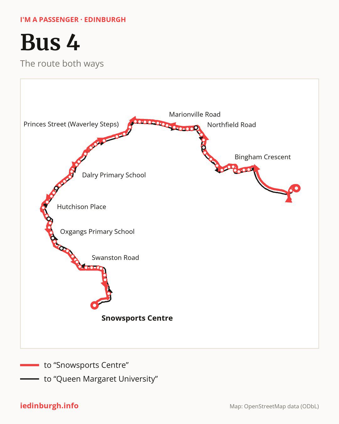
Towards “Snowsports Centre”: 62 stops. After “Queen Margaret University”, the bus calls at “Queen Margaret Drive”, “Milton Link”, “Corbiewynd”, “Parrotshot”, “The Jewel”, “Durham Road South”, “Bingham Crescent”, “Bingham Avenue”, “Duddingston View”, “Duddingston Avenue”. Then “Duddingston Mills”, “Northfield Gardens”, “Northfield Square”, “Northfield Road”, “Royal High Primary”, “Piershill Square East”, “Piershill Square West”, “Meadowbank House”, “Meadowbank Stadium”, “Wishaw Terrace”. Then “Marionville Road”, “Abbeyhill”, “Brunton Place”, “Wellington Street”, “Brunswick Street”, “Leopold Place”, “Leith Street”, “Princes Street (Waverley Steps)”, “Shandwick Place”, “Atholl Crescent”. Then “Haymarket Station”, “Caledonian Village”, “Dalry Primary School”, “Murieston Crescent”, “Springwell House”, “St Michaels Church”, “Shandon Place”, “Hermand Street”, “Hutchison Crossway”, “Hutchison Place”. Then “Slateford Station”, “Allan Park Road”, “Craiglockhart Church”, “Craiglockhart Campus”, “Craiglockhart Park”, “Craiglockhart Road”, “Oxgangs Primary School”, “Colinton Mains Loan”, “Oxgangs Terrace”, “Oxgangs Avenue”. Before “Snowsports Centre”: “Oxgangs Library”, “Cockit Hat”, “New Swanston”, “Swanston Road”, “Caiystane View”, “Fairmile Avenue”, “Fairmilehead Crossroads”, “Swanston Avenue”, “Swanston Drive”, “Golf Club”.
On the way back, from “Snowsports Centre” to “Queen Margaret University”: 64 stops. Only in this direction does it call at “Colinton Mains Road”, “Firrhill High School”, “Craiglockhart Drive”, “Moat Drive”, “Piersfield Terrace” and “Northfield Farm Avenue”. Only in the direction of “Snowsports Centre” does it call at “Northfield Gardens”, “Wishaw Terrace”, “Atholl Crescent” and “Hermand Street”. For the way back, board nearby: “Northfield Gardens” → “Northfield Farm Avenue” (50 m), “Wishaw Terrace” → “Marionville Road” (150 m), “Atholl Crescent” → “Shandwick Place” (250 m) and “Hermand Street” → “Moat Drive” (200 m). Towards “Snowsports Centre”, board nearby: “Colinton Mains Road” → “Colinton Mains Loan” (100 m), “Firrhill High School” → “Oxgangs Primary School” (150 m), “Craiglockhart Drive” → “Craiglockhart Church” (150 m) and “Moat Drive” → “Hermand Street” (200 m).
Left column runs down, right column runs up. Filled stops are served both ways, dashed ones only one way: 5 towards “Snowsports Centre” and 6 the other way. Tap a stop to see its name.
Connections
On part of the route, between “Princes Street (Waverley Steps)” and “Allan Park Road” it shares the road with route 44; between “Northfield Road” and “Leith Street” it shares the road with route 5; between “Piershill Square East” and “Leith Street” it shares the road with route 45.
Connections by stop, in route order:
- “Queen Margaret University”: buses 30, 106 and 111
- “Queen Margaret Drive”: buses 30 and 106
- “Milton Link”: buses 2, 49 and X4
- Stops from “Corbiewynd” to “The Jewel”: buses 2, 21, 49, 106 and X4
- “Durham Road South”: buses 2, 21, 49, 106, 124 and X4
- “Bingham Crescent”: buses 21, 49, 106 and X4
- “Duddingston Avenue”: bus 12
- “Duddingston Mills”: buses 12, 106, 124 and X4
- “Northfield Gardens” (only towards “Snowsports Centre”): buses 12, 106, 124 and X4
- “Northfield Square”: buses 106, 124 and X4
- “Northfield Road”: buses 15, 21 and 26
- “Royal High Primary”: buses 15, 21 and 26
- Stops from “Piershill Square East” to “Meadowbank House”: buses 15, 26, 106, 124 and X4
- “Meadowbank Stadium”: buses 15, 19, 26, 34, 106, 124 and X4
- “Wishaw Terrace” (only towards “Snowsports Centre”): buses 15, 19, 26 and 34
- “Marionville Road”: buses 15, 19, 26, 34, 106, 124 and X4
- Stops from “Abbeyhill” to “Wellington Street”: buses 1, 15, 19, 26, 34, 35, 106, 124 and X4
- “Brunswick Street”: buses 1, 7, 10, 11, 14, 16, 19, 34 and 49
- “Leopold Place”: buses 1, 7, 8, 10, 11, 14, 16, 19, 34 and 49
- “Leith Street”: buses 1, 7, 8, 10, 11, 14, 15, 16, 19, 26, 29, 34, 37, 43, 49, 100, 106, 124, X4 and X19
- “Princes Street (Waverley Steps)”: buses 1, 3, 10, 11, 13, 15, 16, 19, 24, 26, 29, 30, 31, 33, 34, 37, 43, 100, 106, 124, X4 and X19
- “Shandwick Place”: buses 1, 2, 3, 10, 11, 12, 13, 15, 16, 19, 22, 24, 26, 30, 31, 33, 34, 36, 37, 43, 47, 47B, 60, 100, 106, 124, X4 and X19
- “Atholl Crescent” (only towards “Snowsports Centre”): buses 2, 3, 13, 26, 31, 33, 60, 100, X4 and X19
- “Haymarket Station”: buses 2, 3, 12, 22, 26, 30, 31, 33, 60, 100, X4 and X19
- “Caledonian Village”: buses 1, 2, 3, 12, 22, 26, 30, 31, 33, 34, 35, 100 and X19
- “Dalry Primary School”: buses 1, 2, 3, 22, 30, 33, 34 and 35
- Stops from “Murieston Crescent” to “St Michaels Church”: buses 1, 2, 3, 22, 33, 34 and 35
- “Shandon Place”: buses 1, 2, 3, 22, 33, 34, 35 and 38
- “Hermand Street” (only towards “Snowsports Centre”): buses 22, 34, 35 and 38
- “Hutchison Crossway”: buses 22, 34 and 35
- “Hutchison Place”: buses 22, 34 and 35
- “Slateford Station”: buses 20, 22, 34 and 35
- “Allan Park Road”: buses 20, 22, 34, 35 and 36
- “Craiglockhart Church”: buses 10, 20, 34 and 36
- “Craiglockhart Campus”: buses 10 and 36
- “Craiglockhart Park”: buses 10 and 36
- “Craiglockhart Road”: bus 10
- Stops from “Oxgangs Terrace” to “New Swanston”: bus 16
- Stops from “Fairmile Avenue” to “Swanston Drive”: buses 11 and 15
- “Golf Club”: bus 15
- “Firrhill High School” (only towards “Queen Margaret University”): bus 10
- “Craiglockhart Drive” (only towards “Queen Margaret University”): buses 10 and 36
- “Moat Drive” (only towards “Queen Margaret University”): buses 22, 34, 35 and 38
- “Piersfield Terrace” (only towards “Queen Margaret University”): buses 15, 21 and 26
- “Northfield Farm Avenue” (only towards “Queen Margaret University”): buses 12, 106, 124 and X4
Pages for these routes: bus 1, bus 2, bus 3, bus 5, bus 7, bus 8, bus 10, bus 11, bus 12, bus 13, bus 14, bus 15, bus 16, bus 19, bus 20, bus 21, bus 22, bus 24, bus 26, bus 29, bus 30, bus 31, bus 33, bus 34, bus 35, bus 36, bus 37, bus 38, bus 43, bus 44, bus 45, bus 47, bus 47B, bus 49, bus 60, bus 100, bus 106, bus 111.
Passes and concessions
Our page “How to pay for public transport in Edinburgh” describes tickets, passes and concessions, including any differences between modes of transport.
Questions about bus 4
Does bus 4 go to “Meadowbank Stadium”?
Yes, in both directions.
Where can I change from bus 4 to another bus route?
Most routes stop at “Princes Street (Waverley Steps)” (1, 3, 10, 11, 13, 15, 16, 19, 24, 26, 29, 30, 31, 33, 34, 37, 43, 100, 106, 124, X4 and X19) and “Shandwick Place” (1, 2, 3, 10, 11, 12, 13, 15, 16, 19, 22, 24, 26, 30, 31, 33, 34, 36, 37, 43, 47, 47B, 60, 100, 106, 124, X4 and X19). All other stops with connections are listed above.
Checked on 27 September 2026. Source of the route and stops: Lothian Buses.