
Bus route 17 in Edinburgh goes from “Shrubhill” to “Terminal”. The two directions are not quite the same: 8 stops are served in one direction only, which is worth knowing before you travel. The return journey ends at “Ocean Terminal”.
The route of bus 17
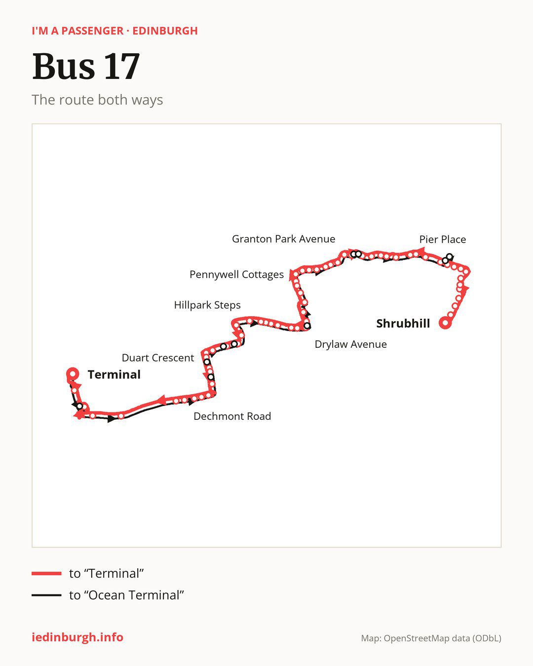
Towards “Terminal”: 63 stops. After “Shrubhill”, the bus calls at “Pilrig Street”, “Balfour Street”, “Foot of the Walk”, “Kirkgate Centre”, “St Anthony Street”, “Parliament Street”, “The Shore”, “Sandport Street”, “Victoria Quay”, “Commercial Street”. Then “North Leith Sands”, “Annfield”, “Fishmarket Square”, “Pier Place”, “Starbank Road”, “Victoria Square”, “St Columbas Hospice”, “Wardie Steps”, “Granton Breakwater”, “Granton Medway”. Then “Granton Park Avenue”, “Royston Mains Road”, “Royston Mains Street”, “Caroline Park Grove”, “Granton Mains East”, “Edinburgh College”, “Waterfront Gait”, “Pennywell Cottages”, “Craigroyston Community High School”, “Muirhouse Hub”. Then “Muirhouse Avenue”, “Craigroyston Health Centre”, “Drylaw Parish Church”, “Drylaw School”, “Drylaw Avenue”, “Forthview Terrace”, “Whitehall Court”, “Blackhall Library”, “Marchfield Terrace”, “Marchfield Park”. Then “Marchfield Park Lane”, “Hillpark Steps”, “Queensferry Road”, “Clermiston Road North”, “Clermiston Crescent”, “Drum Brae Hub”, “Drum Brae Drive”, “Drum Brae North”, “Duart Crescent”, “Drum Brae Park”. Then “Drum Brae Gardens”, “Templeland Road”, “Craigs Avenue”, “Craigs Gardens”, “North Gyle Road”, “Dechmont Road”, “Maybury Road”, “Gogarburn A8”, “Gogarstone Road”, “Ingliston Park & Ride”. Before “Terminal”: “Airport Hotel”.
On the way back, from “Terminal” to “Ocean Terminal”: 56 stops. Only in this direction does it call at, among others, “Eastfield Road”, “Pearce Road”, “Drum Brae Avenue”, “Hoseason Gardens”, “Clermiston View” and “Wester Drylaw Row”. Only in the direction of “Terminal” does it call at, among others, “Pilrig Street”, “Balfour Street”, “Foot of the Walk”, “Kirkgate Centre”, “St Anthony Street” and “Parliament Street”. For the way back, board nearby: “Victoria Quay” → “Ocean Drive” (350 m), “Commercial Street” → “Ocean Drive” (150 m), “Granton Medway” → “Granton Square” (50 m) and “Forthview Terrace” → “Whitehall Court” (200 m). Towards “Terminal”, board nearby: “Eastfield Road” → “Ingliston Park & Ride” (150 m), “Pearce Road” → “Drum Brae Gardens” (150 m), “Drum Brae Avenue” → “Duart Crescent” (150 m) and “Hoseason Gardens” → “Drum Brae Hub” (100 m).
Left column runs down, right column runs up. Filled stops are served both ways, dashed ones only one way: 17 towards “Terminal” and 10 the other way. Tap a stop to see its name.
Other routes along the way
On part of the route, between “Shrubhill” and “Pennywell Cottages” it shares the road with route 16; between “Hillpark Steps” and “Templeland Road” it shares the road with route 21; between “Granton Mains East” and “Drylaw School” it shares the road with route 24.
Connections by stop, in route order:
- “Shrubhill”: buses 7, 10, 11, 13, 14, 25 and 49
- “Pilrig Street” (only towards “Terminal”): buses 7, 11, 13, 14, 25 and 49
- “Balfour Street” (only towards “Terminal”): buses 7, 11, 13, 14, 25, 35 and 49
- “Foot of the Walk” (only towards “Terminal”): buses 7, 14, 25, 35 and 49
- “Kirkgate Centre” (only towards “Terminal”): buses 7, 10, 14, 25, 35, 36 and 49
- “St Anthony Street” (only towards “Terminal”): buses 7, 10, 14, 25, 35, 36 and 49
- “Parliament Street” (only towards “Terminal”): buses 7, 10, 14, 34, 35 and 36
- “The Shore” (only towards “Terminal”): buses 34, 35 and 36
- “Sandport Street” (only towards “Terminal”): buses 34, 35 and 36
- “Victoria Quay” (only towards “Terminal”): buses 7, 10, 14, 34, 35 and 36
- “Commercial Street” (only towards “Terminal”): buses 7, 10, 14, 34, 35 and 36
- “North Leith Sands”: buses 10, 34, 35 and 36
- Stops from “Annfield” to “Pier Place”: buses 7 and 11
- “Victoria Square”: bus 23
- “St Columbas Hospice”: bus 23
- “Wardie Steps”: buses 8, 9 and 14
- “Granton Breakwater”: buses 8, 9, 14, 19 and 22
- “Granton Medway” (only towards “Terminal”): buses 9, 19 and 22
- “Granton Park Avenue”: buses 8, 9, 19 and 22
- “Royston Mains Road”: buses 8, 9, 14, 19 and 22
- Stops from “Royston Mains Street” to “Granton Mains East”: buses 8, 9, 14, 19, 22 and 38
- “Edinburgh College”: buses 8, 9, 14, 22 and 38
- “Waterfront Gait”: buses 8, 9, 14 and 27
- “Pennywell Cottages”: buses 8, 9, 14, 27 and 37
- “Craigroyston Community High School”: buses 8, 9, 14, 27 and 37
- “Muirhouse Hub”: buses 14, 27 and 37
- “Muirhouse Avenue”: buses 14, 27, 29 and 37
- “Craigroyston Health Centre”: buses 27, 29 and 37
- “Drylaw Parish Church”: buses 27, 29 and 37
- “Drylaw Avenue”: buses 13, 43, 47 and 47B
- “Forthview Terrace” (only towards “Terminal”): buses 13, 43, 47 and 47B
- “Whitehall Court”: buses 13, 43, 47 and 47B
- “Blackhall Library”: buses 13, 43, 47 and 47B
- “Marchfield Terrace” (only towards “Terminal”): buses 13, 43, 47 and 47B
- “Marchfield Park”: buses 13, 43, 47 and 47B
- “Marchfield Park Lane”: buses 13, 43, 47 and 47B
- “Hillpark Steps”: buses 43, 47 and 47B
- “Queensferry Road”: bus 43
- “Templeland Road”: buses 12, 31, 100 and X19
- “Craigs Avenue”: buses 12, 31, 100 and X19
- “Craigs Gardens” (only towards “Terminal”): buses 31 and X19
- “North Gyle Road”: buses 31 and X19
- “Dechmont Road”: buses 31, 100 and X19
- “Maybury Road”: buses 18, 22, 31, 36, 100 and X19
- “Gogarburn A8”: buses 18, 70, 71 and X19
- “Gogarstone Road”: buses 18, 70, 71 and X19
- “Ingliston Park & Ride” (only towards “Terminal”): buses 18, 70, 71 and X19
- “Airport Hotel”: buses 18 and 100
- “Terminal”: buses 18 and 100
- “Eastfield Road” (only towards “Ocean Terminal”): buses 18, 70, 71 and X19
- “Granton Square” (only towards “Ocean Terminal”): buses 9, 19 and 22
- “Corinthian Quay” (only towards “Ocean Terminal”): buses 9, 19 and 22
- “Ocean Drive” (only towards “Ocean Terminal”): buses 10, 34, 35 and 36
- “Ocean Terminal”: buses 10, 34, 35 and 36
Pages for these routes: bus 7, bus 8, bus 9, bus 10, bus 11, bus 12, bus 13, bus 14, bus 16, bus 18, bus 19, bus 21, bus 22, bus 23, bus 24, bus 25, bus 27, bus 29, bus 31, bus 34, bus 35, bus 36, bus 37, bus 38, bus 43, bus 47, bus 47B, bus 49, bus 100.
Passes and concessions
Tickets, passes and concessions are covered on a separate page: how to pay for public transport in Edinburgh.
Questions and answers
Does bus 17 go to “Pier Place”?
Yes, in both directions.
Where can I change from bus 17 to another bus route?
Most routes stop at “Shrubhill” (7, 10, 11, 13, 14, 25 and 49) and “Balfour Street” (only towards “Terminal”; 7, 11, 13, 14, 25, 35 and 49). All other stops with connections are listed above.
Checked on 2 October 2026. Source of the route and stops: Lothian Buses.