
Bus route 13 in Edinburgh links “Craigleith Retail Park” and “Lochend Avenue”.
Which way bus 13 runs
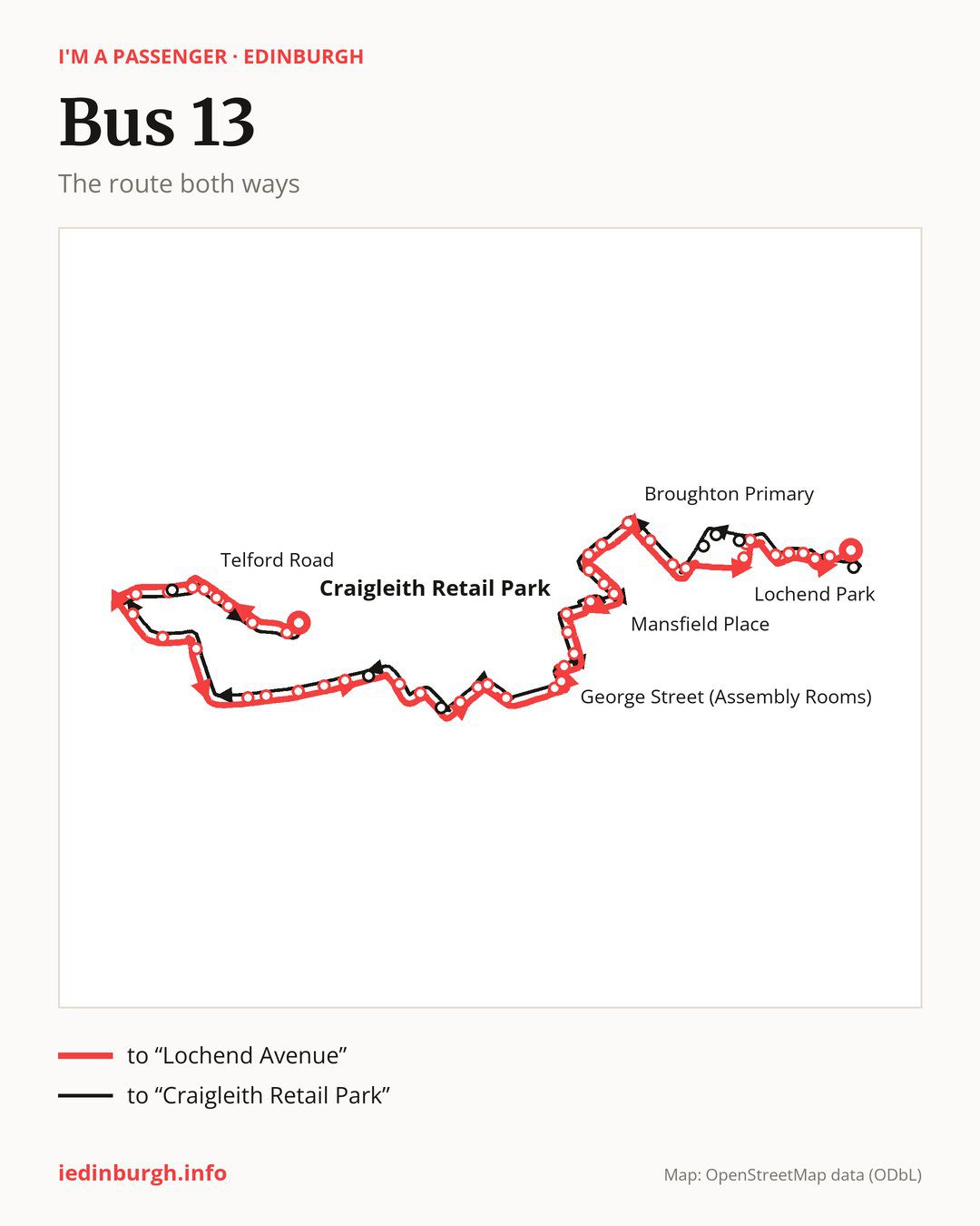
Towards “Lochend Avenue”: 48 stops. After “Craigleith Retail Park”, the bus calls at “Craigleith Road”, “Maidencraig Crescent”, “St Columba’s Church”, “Columba Avenue”, “Telford Road”, “Strachan Road”, “Hillpack Way”, “March Gait”, “Hillpark Green”, “Craigcrook Castle”. Then “Ravelston Dykes Road”, “Mary Erskine School”, “Craigleith Rise”, “Craigleith Crescent”, “Garscube Terrace”, “Orchard Road South”, “Gallery of Modern Art”, “Belford Bridge”, “Chester Street”, “Drumsheugh Gardens”. Then “Drumsheugh Place”, “Queensferry Street”, “Princes Street (west)”, “Frederick Street”, “George Street (Assembly Rooms)”, “Thistle Street”, “Abercromby Place”, “Dundas Street”, “Drummond Place”, “Mansfield Place”. Then “Bellevue Crescent”, “Rodney Street”, “Logie Green Road”, “Beaverhall Road”, “Broughton Primary”, “McDonald Street”, “Hopetoun Crescent”, “Shrubhill”, “Albert Street”, “Dalmeny Street”. Before “Lochend Avenue”: “St Clair Place”, “Albion Place”, “Hawkhill Avenue”, “Lochend Road”, “Lochend Park”, “Hawkhill”.
On the way back, from “Lochend Avenue” to “Craigleith Retail Park”: 47 stops. Only in this direction does it call at, among others, “Sleigh Drive”, “Dickson Street”, “Buchanan Street”, “Pilrig Street”, “Palmerston Place” and “Ravelston Park”. Only in the direction of “Lochend Avenue” does it call at, among others, “Maidencraig Crescent”, “Hillpack Way”, “Garscube Terrace”, “Bellevue Crescent”, “Albert Street” and “Dalmeny Street”. For the way back, board nearby: “Maidencraig Crescent” → “St Columba’s Church” (300 m), “Hillpack Way” → “Hillpark Way” (50 m), “Garscube Terrace” → “Orchard Road South” (200 m) and “Bellevue Crescent” → “Mansfield Place” (150 m). Towards “Lochend Avenue”, board nearby: “Sleigh Drive” → “Lochend Avenue” (150 m), “Dickson Street” → “Dalmeny Street” (50 m), “Buchanan Street” → “Dalmeny Street” (300 m) and “Pilrig Street” → “Shrubhill” (300 m).
Left column runs down, right column runs up. Filled stops are served both ways, dashed ones only one way: 8 towards “Lochend Avenue” and 7 the other way. Tap a stop to see its name.
Connections
On part of the route, between “Thistle Street” and “Rodney Street” it shares the road with route 9; between “Craigleith Road” and “Telford Road” it shares the road with routes 43, 47 and 47B.
Connections by stop, in route order:
- “Craigleith Retail Park”: bus 38
- “Craigleith Road”: bus 38
- “Maidencraig Crescent” (only towards “Lochend Avenue”): bus 38
- Stops from “St Columba’s Church” to “Strachan Road”: bus 17
- “Hillpack Way” (only towards “Lochend Avenue”): bus 17
- “March Gait”: bus 17
- Stops from “Mary Erskine School” to “Craigleith Crescent”: bus 38
- “Chester Street”: buses 3, 4, 19, 22, 25, 26, 31, 33, 36, 37, 44, 60, 106 and X4
- “Drumsheugh Gardens”: buses 3, 4, 19, 22, 25, 26, 31, 33, 36, 37, 44, 100, 106, X4 and X19
- “Drumsheugh Place”: buses 3, 4, 19, 22, 25, 26, 31, 33, 36, 37, 44, 100, 106, X4 and X19
- “Queensferry Street”: buses 1, 3, 4, 10, 11, 12, 15, 16, 19, 22, 24, 25, 26, 30, 31, 33, 34, 36, 37, 44, 100, 106, 124, X4 and X19
- Stops from “Princes Street (west)” to “George Street (Assembly Rooms)”: buses 1, 3, 4, 10, 11, 15, 16, 19, 23, 24, 25, 26, 27, 29, 30, 31, 33, 34, 37, 44, 100, 106, 124, X4 and X19
- “Thistle Street”: buses 1, 3, 4, 10, 11, 15, 16, 19, 23, 24, 25, 26, 27, 29, 30, 31, 33, 34, 37, 44, 100, 124, X4 and X19
- “Abercromby Place”: buses 10, 11, 23, 24, 27 and 29
- “Dundas Street”: buses 23, 24, 27, 29 and 36
- “Drummond Place”: buses 8, 23, 27 and 36
- “Mansfield Place”: bus 8
- “Bellevue Crescent” (only towards “Lochend Avenue”): buses 8 and 36
- “Rodney Street”: buses 8, 23, 27 and 36
- “Logie Green Road”: buses 8, 23, 27 and 36
- “Beaverhall Road”: buses 8 and 36
- “Broughton Primary”: buses 10 and 36
- “McDonald Street”: buses 10 and 36
- “Hopetoun Crescent”: buses 7, 10, 11, 14, 16, 17, 25 and 49
- “Shrubhill”: buses 7, 10, 11, 14, 16, 17, 25 and 49
- “Albert Street” (only towards “Lochend Avenue”): buses 1 and 35
- “Dalmeny Street” (only towards “Lochend Avenue”): buses 1 and 35
- “St Clair Place”: buses 1 and 35
- “Albion Place”: buses 1, 21, 25 and 35
- “Hawkhill Avenue”: buses 21 and 25
- “Lochend Road”: buses 21 and 25
- “Lochend Park” (only towards “Lochend Avenue”): buses 21 and 25
- “Hawkhill” (only towards “Lochend Avenue”): buses 19, 21, 25, 34 and 49
- “Lochend Avenue”: buses 19, 21, 25, 34 and 49
- “Sleigh Drive” (only towards “Craigleith Retail Park”): buses 19, 21, 25, 34 and 49
- “Dickson Street” (only towards “Craigleith Retail Park”): buses 1, 7, 14, 16, 17, 25, 35 and 49
- “Buchanan Street” (only towards “Craigleith Retail Park”): buses 1, 7, 11, 14, 16, 17, 25, 35 and 49
- “Pilrig Street” (only towards “Craigleith Retail Park”): buses 7, 11, 14, 16, 17, 25 and 49
- “Hillpark Way” (only towards “Craigleith Retail Park”): bus 17
Pages for these routes: bus 1, bus 3, bus 4, bus 7, bus 8, bus 9, bus 10, bus 11, bus 12, bus 14, bus 15, bus 16, bus 17, bus 19, bus 21, bus 22, bus 23, bus 24, bus 25, bus 26, bus 27, bus 29, bus 30, bus 31, bus 33, bus 34, bus 35, bus 36, bus 37, bus 38, bus 43, bus 44, bus 47, bus 47B, bus 49, bus 60, bus 100, bus 106.
Passes and concessions
Our page “How to pay for public transport in Edinburgh” describes tickets, passes and concessions, including any differences between modes of transport.
Questions and answers
Does bus 13 go to “Drumsheugh Place”?
Yes, in both directions.
Where can I change from bus 13 to another bus route?
Most routes stop at “Queensferry Street” (1, 3, 4, 10, 11, 12, 15, 16, 19, 22, 24, 25, 26, 30, 31, 33, 34, 36, 37, 44, 100, 106, 124, X4 and X19) and “Princes Street (west)” (1, 3, 4, 10, 11, 15, 16, 19, 23, 24, 25, 26, 27, 29, 30, 31, 33, 34, 37, 44, 100, 106, 124, X4 and X19). All other stops with connections are listed above.
Checked on 24 September 2026. Source of the route and stops: Lothian Buses.