
Bus route 18 in Edinburgh runs between “Fort Kinnaird West” and “Terminal”. In one direction or the other it serves 2 stops that it skips on the way back.
The route of bus 18
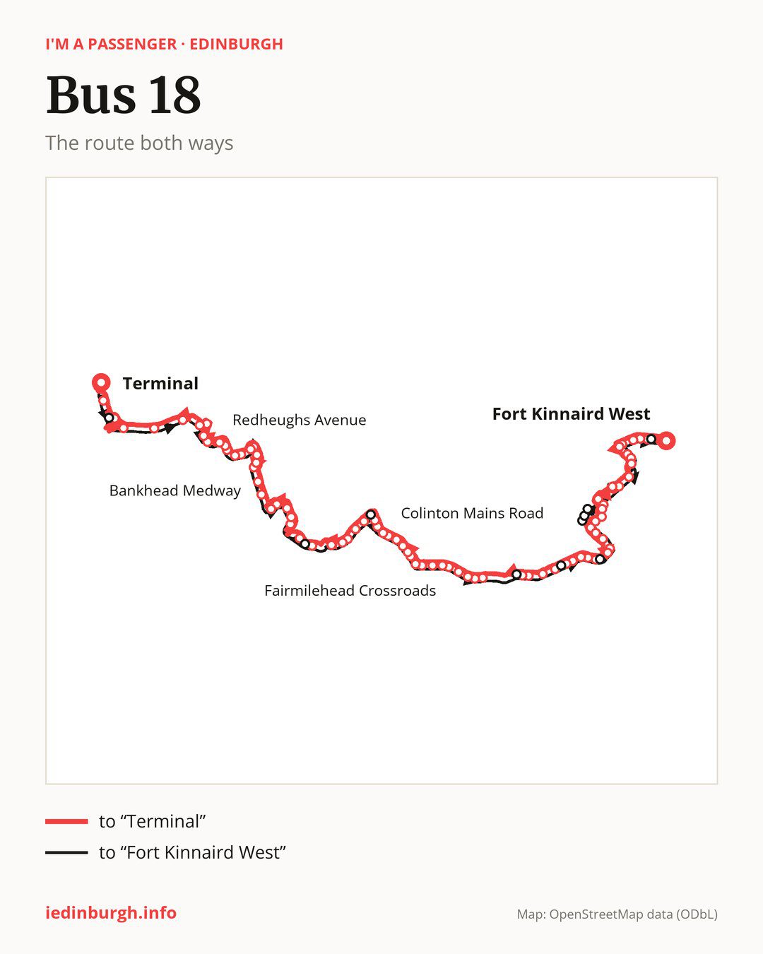
From “Fort Kinnaird West” to “Terminal”: 83 stops. On the way: “Peacocktail Close”, “Jack Kane Centre”, “Hay Drive”, “Hay Avenue”, “Wauchope Road”, “St Teresa Church”, “Niddrie Marischal Drive”, “Niddrie House Avenue”, “Greendykes Terrace”, “Sandilands Close”. Then “SCRM”, “Royal Infirmary”, “Nether Craigour”, “Craigour Drive”, “Craigour Avenue”, “Craigour Grove”, “Moredun Park Drive”, “Moredun Park Road”, “Guardwell Glen”, “Gilmerton Primary School”. Then “Gilmerton Crossroads”, “Newtoft Street”, “Burndale Place”, “Gilmerton Dykes Avenue”, “Gilmerton Dykes Crescent”, “Lasswade Grove”, “Gracemount Leisure Centre”, “Southhouse Loan”, “Kaimes Crossroads”, “Mortonhall Park Gardens”. Then “Mortonhall Park Avenue”, “Marie Curie Hospice”, “Margaret Rose Avenue”, “Winton Drive”, “Frogston Avenue”, “Fairmilehead Crossroads”, “Fairmile Avenue”, “Caiystane View”, “Swanston Road”, “New Swanston”. Then “Cockit Hat”, “Oxgangs Library”, “Oxgangs Avenue”, “Oxgangs Terrace”, “Colinton Mains Road”, “Colinton Mains Loan”, “Oxgangs Primary School”, “Firrhill High School”, “Elliot Road”, “Redford Barracks”. Then “Merchiston Castle School”, “Rustic Cottages”, “Colinton Village”, “Spylaw Bank”, “Viewfield Road”, “Clovenstone Road”, “Wester Hailes Park”, “Hailesland Place”, “Murrayburn Park”, “Westside Plaza”. Then “Calder Drive”, “Bankhead Loan”, “Bankhead Medway”, “Edinburgh College (Sighthill)”, “Bankhead Drive”, “Forrester High School”, “Gyle Square”, “South Gyle Trade Park”, “South Gyle Crescent Lane”, “Teviot House”. Then “Drummond House”, “Redheughs Avenue”, “Lochside Place”, “Lochside Crescent”, “Gyle Centre”, “Gyle Roundabout”, “Gogar Roundabout”, “Gogarburn A8”, “Gogarstone Road”, “Ingliston Park & Ride”. Before “Terminal”: “Airport Hotel”.
The return journey is different. Towards “Fort Kinnaird West”: 83 stops. Only in this direction does it call at, among others, “Eastfield Road”, “Cross Road”, “Elliot Place”, “Mortonhall Gate”, “Gracemount Drive” and “Hyvot Park”. Only in the direction of “Terminal” does it call at, among others, “St Teresa Church”, “Craigour Drive”, “Craigour Avenue”, “Craigour Grove”, “Moredun Park Drive” and “Winton Drive”. For the way back, board nearby: “St Teresa Church” → “Wauchope Road” (100 m), “Craigour Drive” → “Nether Craigour” (200 m), “Craigour Avenue” → “Nether Craigour” (300 m) and “Moredun Park Drive” → “Moredun Park Road” (200 m). Towards “Terminal”, board nearby: “Eastfield Road” → “Ingliston Park & Ride” (150 m), “Cross Road” → “Spylaw Bank” (200 m), “Elliot Place” → “Firrhill High School” (200 m) and “Mortonhall Gate” → “Mortonhall Park Avenue” (150 m).
Left column runs down, right column runs up. Filled stops are served both ways, dashed ones only one way: 10 towards “Terminal” and 10 the other way. Tap a stop to see its name.
Other routes along the way
Shared sections with other routes: between “Burndale Place” and “Fairmilehead Crossroads” it shares the road with route 11; between “Fairmilehead Crossroads” and “Firrhill High School” it shares the road with route 4; between “Jack Kane Centre” and “Royal Infirmary” it shares the road with route 21.
Connections by stop, in route order:
- “Fort Kinnaird West”: buses 30, 49 and 106
- “Peacocktail Close”: buses 2, 30 and 106
- Stops from “Jack Kane Centre” to “Hay Avenue”: buses 2 and 30
- “Wauchope Road”: buses 2, 14 and 30
- “St Teresa Church” (only towards “Terminal”): buses 2, 14 and 30
- “Niddrie Marischal Drive”: buses 2, 14 and 30
- “Niddrie House Avenue”: bus 14
- “Greendykes Terrace”: buses 14 and 111
- “Sandilands Close”: buses 14 and 111
- “SCRM”: buses 8, 24, 33, 38, 49 and 111
- “Royal Infirmary”: buses 8, 24, 33, 38, 49 and 111
- “Nether Craigour”: buses 8, 24, 33, 38 and 49
- “Craigour Drive” (only towards “Terminal”): buses 8 and 33
- “Craigour Avenue” (only towards “Terminal”): buses 8 and 33
- “Craigour Grove” (only towards “Terminal”): bus 8
- “Moredun Park Drive” (only towards “Terminal”): buses 8 and 29
- “Moredun Park Road”: buses 8 and 29
- “Guardwell Glen”: buses 8 and 29
- Stops from “Gilmerton Primary School” to “Newtoft Street”: bus 29
- Stops from “Gilmerton Dykes Avenue” to “Gracemount Leisure Centre”: bus 31
- “Southhouse Loan”: buses 37, 47 and 47B
- “Kaimes Crossroads”: buses 37, 47 and 47B
- Stops from “Frogston Avenue” to “Fairmile Avenue”: bus 15
- “Swanston Road”: bus 5
- Stops from “New Swanston” to “Oxgangs Terrace”: buses 5 and 16
- “Firrhill High School” (only towards “Terminal”): buses 10 and 45
- “Elliot Road”: buses 10 and 45
- “Redford Barracks”: buses 10 and 45
- Stops from “Merchiston Castle School” to “Colinton Village”: buses 10, 16 and 45
- “Spylaw Bank”: buses 20, 44 and 45
- “Viewfield Road”: buses 20, 30, 44 and 45
- Stops from “Clovenstone Road” to “Westside Plaza”: buses 20, 30 and 33
- “Calder Drive”: buses 20, 25, 32, 33, 34, 35 and 36
- “Bankhead Loan”: buses 25, 32, 33, 34, 35 and 36
- “Bankhead Medway”: buses 2, 12, 22, 32 and 36
- “Edinburgh College (Sighthill)”: buses 2, 12, 22, 32 and 36
- “Bankhead Drive” (only towards “Terminal”): buses 2, 12 and 22
- “Forrester High School”: buses 2, 12 and 22
- “Gyle Square”: buses 2, 12 and 22
- “South Gyle Trade Park”: buses 2, 12, 22, 32 and 36
- “South Gyle Crescent Lane”: buses 2, 32 and 36
- “Teviot House”: buses 12 and 22
- “Drummond House”: buses 12 and 22
- “Redheughs Avenue”: buses 12, 22, 32 and 36
- “Lochside Place”: buses 12, 22, 32 and 36
- “Lochside Crescent”: buses 12, 22, 32, 36, 70 and 71
- “Gyle Centre”: buses 12, 17, 22, 31, 32, 36, 70, 71, 100 and X19
- “Gyle Roundabout”: buses 12, 22, 32, 36, 70 and 71
- Stops from “Gogar Roundabout” to “Gogarstone Road”: buses 17, 70, 71 and X19
- “Ingliston Park & Ride” (only towards “Terminal”): buses 17, 70, 71 and X19
- “Airport Hotel”: buses 17 and 100
- “Terminal”: buses 17 and 100
- “Eastfield Road” (only towards “Fort Kinnaird West”): buses 17, 70, 71 and X19
- “Cross Road” (only towards “Fort Kinnaird West”): buses 20, 30, 44 and 45
- “Elliot Place” (only towards “Fort Kinnaird West”): buses 10 and 45
- “Moredun Park Gardens” (only towards “Fort Kinnaird West”): buses 8 and 29
- “Moredunvale Green” (only towards “Fort Kinnaird West”): buses 8 and 29
- “Moredunvale Loan” (only towards “Fort Kinnaird West”): bus 8
- “Niddrie Mill Avenue” (only towards “Fort Kinnaird West”): buses 2 and 30
Pages for these routes: bus 2, bus 4, bus 5, bus 8, bus 10, bus 11, bus 12, bus 14, bus 15, bus 16, bus 17, bus 20, bus 21, bus 22, bus 24, bus 25, bus 29, bus 30, bus 31, bus 32, bus 33, bus 34, bus 35, bus 36, bus 37, bus 38, bus 44, bus 45, bus 47, bus 47B, bus 49, bus 100, bus 106, bus 111.
Passes and concessions
Tickets, passes and concessions are covered on a separate page: how to pay for public transport in Edinburgh.
Questions about bus 18
Does bus 18 go to “Moredun Park Road”?
Yes, in both directions.
Where can I change from bus 18 to another bus route?
Most routes stop at “Calder Drive” (20, 25, 32, 33, 34, 35 and 36) and “Gyle Centre” (12, 17, 22, 31, 32, 36, 70, 71, 100 and X19). All other stops with connections are listed above.
Checked on 5 October 2026. Source of the route and stops: Lothian Buses.