
Bus route 24 in Edinburgh links “Waterfront Broadway” and “Royal Infirmary”.
Which way bus 24 runs
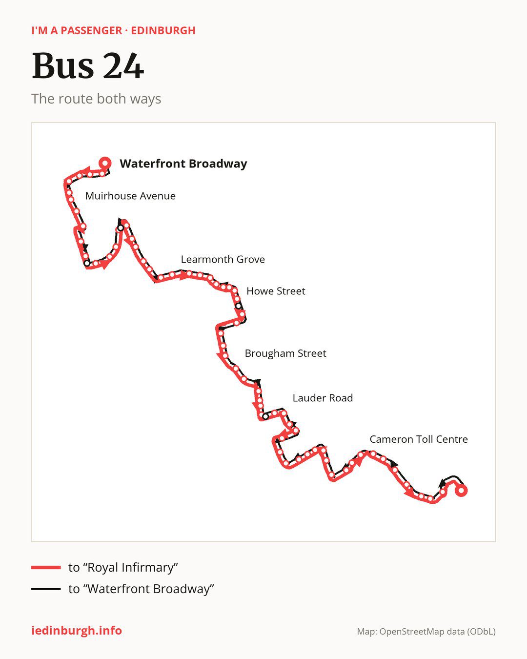
Towards “Royal Infirmary”: 65 stops. After “Waterfront Broadway”, the bus calls at “Granton Mains East”, “Edinburgh College”, “Waterfront Gait”, “Pennywell Cottages”, “Craigroyston Community High School”, “Muirhouse Hub”, “Muirhouse Avenue”, “Craigroyston Health Centre”, “Drylaw Parish Church”, “Drylaw School”. Then “Groathill Road South”, “Telford Drive”, “Telford Gardens”, “Telford Place”, “Crewe Toll”, “North Werber Park”, “West Woods”, “Western General”, “Comely Bank Cemetery”, “Flora Stevenson School”. Then “Learmonth Grove”, “Dean Park Street”, “Cheyne Street”, “Raeburn Place”, “Kerr Street”, “Circus Lane”, “Royal Circus”, “Howe Street”, “Queen Street Gardens West”, “Frederick Street”. Then “Princes Street (west)”, “Lothian Road”, “Usher Hall”, “Bread Street”, “Brougham Street”, “Leven Terrace”, “Warrender Park Terrace”, “Warrender Park Road”, “Spottiswoode Road”, “Thirlestane Road”. Then “Grange Cemetery”, “Lauder Road”, “Dick Place”, “Dalrymple Crescent”, “St Thomas Road”, “South Oswald Road”, “Blackford Avenue”, “Watertoun Road”, “Langton Road”, “Savile Place”. Then “West Savile Road”, “Lussielaw Road”, “Rankin Drive”, “Gordon Terrace”, “Lady Road”, “Cameron Toll Centre”, “Cameron Toll”, “Bridgend Cottages”, “Craigmillar Cemetery”, “Walter Scott Avenue”. Before “Royal Infirmary”: “Kingston Avenue”, “Craigmillar Castle Road”, “RH for Children & Young People”.
On the way back, from “Royal Infirmary” to “Waterfront Broadway”: 64 stops. Only in this direction does it call at “Beaufort Road”, “Hill Street”, “Telford Grove” and “Wester Drylaw Row”. Only in the direction of “Royal Infirmary” does it call at “Cheyne Street”, “Circus Lane”, “Queen Street Gardens West”, “West Savile Road” and “Lady Road”. For the way back, board nearby: “Cheyne Street” → “Raeburn Place” (200 m), “Circus Lane” → “Royal Circus” (100 m), “Queen Street Gardens West” → “Hill Street” (150 m) and “West Savile Road” → “Savile Place” (150 m). Towards “Royal Infirmary”, board nearby: “Beaufort Road” → “Thirlestane Road” (100 m), “Hill Street” → “Queen Street Gardens West” (150 m), “Telford Grove” → “Telford Place” (50 m) and “Wester Drylaw Row” → “Drylaw School” (150 m).
Left column runs down, right column runs up. Filled stops are served both ways, dashed ones only one way: 5 towards “Royal Infirmary” and 4 the other way. Tap a stop to see its name.
Connections
On part of the route, between “Crewe Toll” and “Princes Street (west)” it shares the road with route 29; between “Gordon Terrace” and “Royal Infirmary” it shares the road with route 38; between “Granton Mains East” and “Drylaw School” it shares the road with route 17.
Connections by stop, in route order:
- “Waterfront Broadway”: buses 8, 9, 14, 16 and 22
- “Granton Mains East”: buses 8, 9, 14, 16, 19 and 22
- “Edinburgh College”: buses 8, 9, 14, 16 and 22
- “Waterfront Gait”: buses 8, 9, 14, 16 and 27
- “Pennywell Cottages”: buses 8, 9, 14, 16, 27 and 37
- “Craigroyston Community High School”: buses 8, 9, 14, 16, 27 and 37
- “Muirhouse Hub”: buses 14, 16, 27 and 37
- “Muirhouse Avenue”: buses 14, 21, 27 and 37
- “Craigroyston Health Centre”: buses 21, 27 and 37
- “Drylaw Parish Church”: buses 21, 27 and 37
- “Telford Gardens”: buses 19, 22, 37 and 106
- “Telford Place”: buses 19, 21, 22, 27 and 37
- “Crewe Toll”: buses 19, 21, 22, 27 and 37
- Stops from “North Werber Park” to “Learmonth Grove”: buses 19, 22, 37 and 106
- “Dean Park Street”: bus 36
- “Cheyne Street” (only towards “Royal Infirmary”): bus 36
- “Raeburn Place”: bus 36
- “Kerr Street”: bus 36
- “Circus Lane” (only towards “Royal Infirmary”): bus 36
- “Royal Circus”: buses 9, 13, 23, 27 and 36
- “Howe Street”: buses 9, 10, 11, 13, 23 and 27
- “Queen Street Gardens West” (only towards “Royal Infirmary”): buses 9, 10, 11, 13, 23 and 27
- “Frederick Street”: buses 1, 3, 4, 9, 10, 11, 13, 15, 16, 19, 23, 25, 26, 27, 30, 31, 34, 37, 43, 44, 100, 106, 124, X4 and X19
- “Princes Street (west)”: buses 1, 3, 4, 9, 10, 11, 13, 15, 16, 19, 22, 23, 25, 26, 27, 30, 31, 34, 36, 37, 43, 44, 47, 47B, 100, 106, 124, X4 and X19
- “Lothian Road”: buses 1, 3, 4, 10, 11, 12, 13, 15, 16, 19, 22, 25, 26, 30, 31, 34, 36, 37, 43, 44, 47, 47B, 100, 106, 124, X4 and X19
- “Usher Hall”: buses 1, 2, 10, 11, 12, 15, 16, 22, 23, 26, 27, 30, 31, 34, 35, 36, 45, 47, 47B, 60, 124 and X19
- “Bread Street”: buses 1, 2, 10, 11, 12, 15, 16, 22, 23, 27, 30, 34, 35, 36, 45, 47, 47B, 60 and 124
- “Brougham Street”: buses 1, 2, 10, 11, 12, 15, 16, 23, 27, 34, 35, 36, 45, 47, 47B, 60 and 124
- “Leven Terrace”: buses 10, 11, 12, 15, 16, 23, 27, 35, 36, 45, 47, 47B and 60
- “Warrender Park Terrace”: bus 9
- Stops from “Warrender Park Road” to “Grange Cemetery”: buses 5 and 9
- “Lauder Road”: bus 5
- “Dick Place”: bus 5
- Stops from “St Thomas Road” to “Watertoun Road”: bus 9
- “Langton Road”: bus 12
- “Savile Place”: bus 12
- “West Savile Road” (only towards “Royal Infirmary”): buses 3, 7, 8, 12, 31, 37, 47 and 47B
- “Lussielaw Road”: bus 12
- “Rankin Drive”: buses 9 and 12
- “Gordon Terrace”: buses 3, 7, 8, 12, 31, 37, 47 and 47B
- “Lady Road” (only towards “Royal Infirmary”): buses 3, 7, 8, 12, 31, 37, 47 and 47B
- “Cameron Toll Centre”: buses 3, 7, 8, 12, 31, 37, 47 and 47B
- “Cameron Toll”: bus 12
- “Bridgend Cottages”: bus 12
- “Kingston Avenue”: buses 7 and 8
- “Craigmillar Castle Road”: buses 7, 8 and 18
- “RH for Children & Young People”: buses 7, 8 and 18
- “Royal Infirmary”: buses 7, 8, 18, 21 and 111
- “Beaufort Road” (only towards “Waterfront Broadway”): buses 5 and 9
- “Hill Street” (only towards “Waterfront Broadway”): buses 1, 4, 9, 10, 11, 13, 15, 16, 19, 23, 25, 26, 27, 34, 37, 43, 44, 100, 106, 124, X4 and X19
- “Telford Grove” (only towards “Waterfront Broadway”): buses 19, 21, 22, 27 and 37
Pages for these routes: bus 1, bus 2, bus 3, bus 4, bus 5, bus 7, bus 8, bus 9, bus 10, bus 11, bus 12, bus 13, bus 14, bus 15, bus 16, bus 17, bus 18, bus 19, bus 21, bus 22, bus 23, bus 25, bus 26, bus 27, bus 29, bus 30, bus 31, bus 34, bus 35, bus 36, bus 37, bus 38, bus 43, bus 44, bus 45, bus 47, bus 47B, bus 60, bus 100, bus 106, bus 111.
Passes and concessions
Tickets, passes and concessions are covered on a separate page: how to pay for public transport in Edinburgh.
Questions about bus 24
Does bus 24 go to “Edinburgh College”?
Yes, in both directions.
Where can I change from bus 24 to another bus route?
Most routes stop at “Princes Street (west)” (1, 3, 4, 9, 10, 11, 13, 15, 16, 19, 22, 23, 25, 26, 27, 30, 31, 34, 36, 37, 43, 44, 47, 47B, 100, 106, 124, X4 and X19) and “Lothian Road” (1, 3, 4, 10, 11, 12, 13, 15, 16, 19, 22, 25, 26, 30, 31, 34, 36, 37, 43, 44, 47, 47B, 100, 106, 124, X4 and X19). All other stops with connections are listed above.
Checked on 24 September 2026. Source of the route and stops: Lothian Buses.