

Bus route 34 in Edinburgh runs between “Ocean Terminal” and “The Avenue”.
Which way bus 34 runs
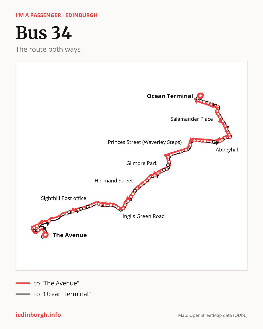
From “Ocean Terminal” to “The Avenue”: 56 stops. On the way: “Commercial Street”, “Victoria Quay”, “Sandport Street”, “Bernard Street”, “Elbe Street”, “Salamander Place”, “Links Gardens”, “Gladstone Place”, “Ryehill Terrace”, “Restalrig Circus”. Then “Lochend Avenue”, “Sleigh Drive”, “Restalrig Gardens”, “Marionville Drive”, “Marionville Avenue”, “Marionville Park”, “Dalgety Avenue”, “Abbeyhill”, “Brunton Place”, “Wellington Street”. Then “Brunswick Street”, “Leopold Place”, “Leith Street”, “Princes Street (Waverley Steps)”, “Lothian Road”, “Usher Hall”, “Port Hamilton”, “Gilmore Park”, “Fountain Park”, “Dundee Terrace”. Then “Angle Park Terrace”, “St Michaels Church”, “Shandon Place”, “Hermand Street”, “Hutchison Crossway”, “Hutchison Place”, “Slateford Station”, “Allan Park Road”, “Water of Leith Centre”, “Inglis Green Road”. Then “Longstone Park”, “Longstone Crescent”, “Longstone Gardens”, “Longstone Terrace”, “Parkhead Terrace”, “Sighthill Post office”, “Sighthill Gardens”, “Napier University (Sighthill)”, “Wester Hailes Road”, “Calder View”. Before “The Avenue”: “Hermiston Park & Ride”, “Research Avenue North”, “Jack Copland Centre”, “Boundary Road North”.
The return journey is different. Towards “Ocean Terminal”: 58 stops. Only in this direction does it call at, among others, “Heriot Watt Campus”, “Burtons Biscuits Factory”, “Sighthill Green”, “Broomhouse Road”, “Moat Drive” and “Grove Street”. Only in the direction of “The Avenue” does it call at, among others, “Gladstone Place”, “Hermand Street”, “Longstone Gardens”, “Parkhead Terrace”, “Sighthill Gardens” and “Wester Hailes Road”. For the way back, board nearby: “Gladstone Place” → “Links Gardens” (200 m), “Hermand Street” → “Moat Drive” (200 m), “Longstone Gardens” → “Longstone Terrace” (150 m) and “Parkhead Terrace” → “Longstone Terrace” (150 m). Towards “The Avenue”, board nearby: “Heriot Watt Campus” → “The Avenue” (200 m), “Burtons Biscuits Factory” → “Calder View” (150 m), “Sighthill Green” → “Napier University (Sighthill)” (150 m) and “Broomhouse Road” → “Sighthill Post office” (200 m).
Left column runs down, right column runs up. Filled stops are served both ways, dashed ones only one way: 8 towards “The Avenue” and 9 the other way. Tap a stop to see its name.
Where to change
Shared sections with other routes: between “Sleigh Drive” and “Princes Street (Waverley Steps)” it shares the road with route 19; between “Brunton Place” and “Dundee Terrace” it shares the road with route 1; between “Port Hamilton” and “Slateford Station” it shares the road with route 35.
Connections by stop, in route order:
- “Ocean Terminal”: buses 10, 16 and 17
- “Commercial Street”: buses 7, 10, 14, 16, 17 and 21
- “Victoria Quay”: buses 7, 10, 14, 16, 17 and 21
- “Sandport Street”: buses 16 and 17
- “Bernard Street”: buses 16 and 17
- “Salamander Place”: bus 49
- “Links Gardens”: bus 49
- “Gladstone Place” (only towards “The Avenue”): bus 49
- “Ryehill Terrace”: bus 49
- “Restalrig Circus”: buses 13, 21 and 49
- Stops from “Lochend Avenue” to “Marionville Drive”: buses 13, 21, 25 and 49
- “Marionville Avenue”: buses 13 and 25
- “Marionville Park”: buses 5, 15, 25, 26 and 45
- “Dalgety Avenue”: buses 5, 15, 25, 26, 45, 106, 124 and X4
- Stops from “Abbeyhill” to “Wellington Street”: buses 5, 15, 26, 45, 106, 124 and X4
- “Brunswick Street”: buses 5, 7, 10, 11, 14, 16, 25, 45 and 49
- “Leopold Place”: buses 5, 7, 8, 10, 11, 14, 16, 25, 45 and 49
- “Leith Street”: buses 5, 7, 8, 10, 11, 14, 15, 16, 25, 26, 29, 37, 43, 45, 49, 100, 106, 124, X4 and X19
- “Princes Street (Waverley Steps)”: buses 3, 10, 11, 13, 15, 16, 24, 25, 26, 29, 30, 31, 33, 37, 43, 100, 106, 124, X4 and X19
- “Lothian Road”: buses 3, 10, 11, 12, 13, 15, 16, 22, 24, 25, 26, 30, 31, 33, 37, 43, 47, 47B, 100, 106, 124, X4 and X19
- “Usher Hall”: buses 2, 10, 11, 12, 15, 16, 22, 23, 24, 26, 27, 30, 31, 45, 47, 47B, 60, 124 and X19
- “Port Hamilton”: buses 2, 10, 11, 12, 15, 16, 23, 24, 27, 45, 47, 47B, 60 and 124
- “Gilmore Park”: buses 10, 22, 27 and 30
- “Fountain Park”: buses 2, 3, 10, 22, 25, 27, 30 and 33
- “Dundee Terrace”: buses 2, 3, 10, 22, 25, 27, 30 and 33
- “Angle Park Terrace”: buses 2, 3, 10, 22, 25, 27 and 33
- “St Michaels Church”: buses 2, 3, 22, 25 and 33
- “Shandon Place”: buses 2, 3, 22, 25, 33 and 38
- “Hermand Street” (only towards “The Avenue”): buses 22 and 38
- “Hutchison Crossway”: bus 22
- “Hutchison Place”: bus 22
- “Slateford Station”: buses 20 and 22
- “Allan Park Road”: buses 20 and 22
- Stops from “Water of Leith Centre” to “Longstone Park”: bus 20
- “Longstone Crescent”: buses 20 and 30
- “Longstone Gardens” (only towards “The Avenue”): buses 3, 25, 30 and 33
- “Longstone Terrace”: buses 3, 25, 30 and 33
- “Parkhead Terrace” (only towards “The Avenue”): buses 3, 25, 30 and 33
- “Sighthill Post office”: buses 3, 25 and 33
- “Sighthill Gardens” (only towards “The Avenue”): buses 3, 25 and 33
- “Napier University (Sighthill)”: buses 3, 18, 20, 25, 32 and 33
- “Wester Hailes Road” (only towards “The Avenue”): buses 3, 18, 20, 25, 32 and 33
- “Calder View” (only towards “The Avenue”): buses 20, 25 and 32
- “Hermiston Park & Ride”: buses 25, 32 and 70
- “Research Avenue North”: bus 70
- “The Avenue”: buses 25, 32 and 45
- “Heriot Watt Campus” (only towards “Ocean Terminal”): buses 25, 32 and 45
- “Burtons Biscuits Factory” (only towards “Ocean Terminal”): buses 18, 20, 25 and 32
- “Sighthill Green” (only towards “Ocean Terminal”): buses 3, 25 and 33
- “Broomhouse Road” (only towards “Ocean Terminal”): buses 3, 25 and 33
- “Moat Drive” (only towards “Ocean Terminal”): buses 22 and 38
- “Grove Street” (only towards “Ocean Terminal”): buses 2, 10, 22, 27, 30, 60 and 124
- “Semple Street” (only towards “Ocean Terminal”): buses 2, 10, 11, 12, 15, 16, 22, 23, 24, 27, 30, 45, 47, 47B, 60 and 124
- “Marionville Road” (only towards “Ocean Terminal”): buses 5, 15, 26, 45, 106, 124 and X4
- “Ocean Drive” (only towards “Ocean Terminal”): buses 10, 16 and 17
Pages for these routes: bus 1, bus 2, bus 3, bus 5, bus 7, bus 8, bus 10, bus 11, bus 12, bus 13, bus 14, bus 15, bus 16, bus 17, bus 18, bus 19, bus 20, bus 21, bus 22, bus 23, bus 24, bus 25, bus 26, bus 27, bus 29, bus 30, bus 31, bus 32, bus 33, bus 35, bus 37, bus 38, bus 43, bus 45, bus 47, bus 47B, bus 49, bus 60, bus 100, bus 106.
Passes and concessions
Tickets, passes and concessions are covered on a separate page: how to pay for public transport in Edinburgh.
Questions and answers
Does bus 34 go to “Salamander Place”?
Yes, in both directions.
Where can I change from bus 34 to another bus route?
Most routes stop at “Leith Street” (5, 7, 8, 10, 11, 14, 15, 16, 25, 26, 29, 37, 43, 45, 49, 100, 106, 124, X4 and X19) and “Lothian Road” (3, 10, 11, 12, 13, 15, 16, 22, 24, 25, 26, 30, 31, 33, 37, 43, 47, 47B, 100, 106, 124, X4 and X19). All other stops with connections are listed above.
Checked on 5 October 2026. Source of the route and stops: Lothian Buses.